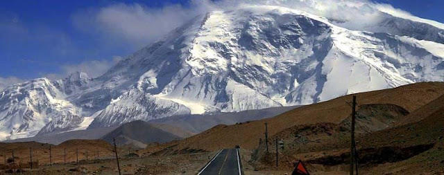
K2 (8611m)
K2 second highest mountain in the world and the most dangerous mountain to climb.
Altitude: 8611m
Base Camp Altitude: 5000m
Location: Pak/China Border
Range: Karakorum
Ideal Duration: 60Days
Best Time: June-August
No of Camps Required: 04
Location: Pak/China Border
Range: Karakorum
Ideal Duration: 60Days
Best Time: June-August
No of Camps Required: 04
First
ascent: July 31, 1954 by Achille Compagnoni and Lino Lacedelli
Introduction:
K2, Chinese Qogir Feng, also called Mount Godwin Austen, called locally Dapsang or Chogori, the world’s second highest peak (28,251 feet [8,611 meters]), second only to Mount Everest. K2 is located in the Karakoram Range and lies partly in a Chinese-administered enclave of the Kashmir region within the Uygur Autonomous Region of Xinjiang of China and partly in the Gilgit-Baltistan portion of Kashmir under the administration of Pakistan.
The glacier- and snow-covered mountain rises from its base at about 15,000 feet (4,570 meters) on the Godwin Austen Glacier (another name for K2), a tributary of the Baltoro Glacier. The mountain was discovered and measured in 1856 by Col. T.G. Montgomerie of the Survey of India, and it was given the symbol K2 because it was the second peak measured in the Karakorum Range. The name Mount Godwin Austen is for the peak’s first surveyor, Col. H.H. Godwin Austen, a 19th-century English geographer. The first attempt to reach the summit was made by an Anglo-Swiss expedition in 1902 that ascended to 18,600 feet (5,670 meters) on the peak’s northeastern crest. Other unsuccessful attempts included an Italian expedition in 1909, led by Luigi Amedeo, duke d’Abruzzi, via the southeastern ridge (later called the Abruzzi Ridge) that reached approximately 20,000 feet (6,100 meters). In 1938 an American expedition led by Charles Houston via the Abruzzi Ridge reached about 26,000 feet (7,925 meters); in 1939 another American-led expedition following the same route reached about 27,500 feet (8,380 meters); and in 1953 another expedition led by Houston reached 25,900 feet (7,900 meters) on the Abruzzi Ridge. Finally, in 1954, an Italian expedition consisting of five scientists (including the geologist Ardito Desio as leader), a doctor, a photographer, and 12 others, including a Pakistani, managed to conquer the Abruzzi Ridge despite the severe weather conditions. The summit was reached at 6 pm on July 31, 1954, by Achille Compagnoni and Lino Lacedelli.
 |
| K2 |
 |
| K2 |
Itinerary:
Day 01: Arrival at Islamabad,
Transfer to Hotel
Day 02: Briefing at Ministry of tourism and City tour.
Day 03: Drive to Chilas 14,15 hours. Overnight hotel
Day 04: Drive to Skardu 12 hours. KKH, overnight hotel
Day 05: Rest Day at Skardu. Overnight hotel
Day 06: Drive to Askoli by Jeep, 7-8 hours. Overnight camp
Day 07: Trek to Junla 7 hours. Overnight camp
Day 08: Trek to Paju. 7 hours. Overnight camp
Day 09: Paju Rest Day. Overnight camp
Day 10: Trek to Urdukas 8-9 hours. Overnight camp
Day 11: Trek to Goro II. 5-6 hours.
Day 12: Trek to Broad Peak BC, 8-9 hours. Overnight camp
Day 13: Trek to K2 Base camp. 2 hours. Overnight camp
Day 14: Rest day B.C.
Day 15: Climbing 38 days.
Day 53: Ali Camp
Day 54: Cross Godogoro La to Goloung
Day 55: Goloung to Hushe/Kanday
Day 56: Hushe/Kanday to Skardu
Day 57: Skardu to Islamabad by fly or drive to Chilas
Day 58: free day or Drive to Islamabad
Day 59: De-briefing at Ministry of Tourism
Day 60: Fly out
 |
| K2 |
If you want to get information how to get Pakistan visit:
Thanks you for reading, please like and comment :)

.jpg)

Comments
Post a Comment